I came across this particular anomaly in a parish boundary entirely by chance. I was walking from Arnesby, via Arnesby Lodge Farm, north towards Wistow one afternoon in the summer of 2022. This is the area, on a 1:50,000 scale and ‘zooming in’ on a 1:25,000 scale:

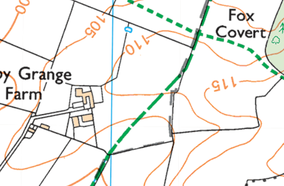
This is my favourite type of map for walking – I’m a big fan of the Ordnance Survey’s “Explorer” series at a scale of 1:25,000, because it has field boundaries, so you’d struggle to get lost.
North is at the top of the map. I crossed the Fleckney Road and walked north along the bridleway (the long green dashed line) into a field, with the hedge line (the thin black line) on my right.
I crossed a stile. Kilby Grange Farm was ahead of me to my left, and as I walked along the bridleway up a gentle slope I spotted, directly ahead of me on the skyline a series of lumps and bumps, stretched out on an east-west axis on the 110m contour.
As I reached the feature the farm was to my left. Immediately to my right, the field boundary had an interesting ‘kink’ – on same 110m contour line – and the hedge line coincided with the parish boundary (the long grey dashed line.)
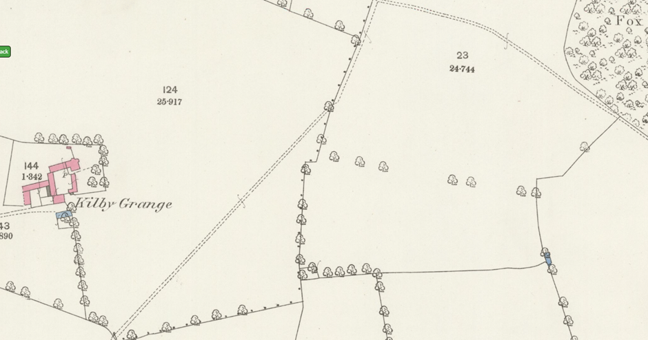
The ‘kink’ is clear on the 1:25,000 map, and it’s much more obvious on the old six- and twenty-five-inch maps (the single dots are the parish boundary; Kilby to the west, Wistow to the east.) There’s also an old tree line recorded, presumably the line of an old hedgerow, in the next field to the west, ending at the kink in our field.
Kilby Grange Farm – 25 inch scale map (1885):

Light Detection and Ranging (“LIDAR”)
95% of England has now been mapped by LIDAR. If you’ve not come across it before, it works on the same principle as radar, but using laser light instead of radio waves. Because laser light has a much shorter wavelength, it can resolve much smaller features. In the image above, you can clearly see field boundaries, ditches, buildings and, in the left-hand part of the image, medieval ridge and furrow plough scars. Modern deep ploughing has ‘smoothed out’ field surfaces in the right-hand part of the image.
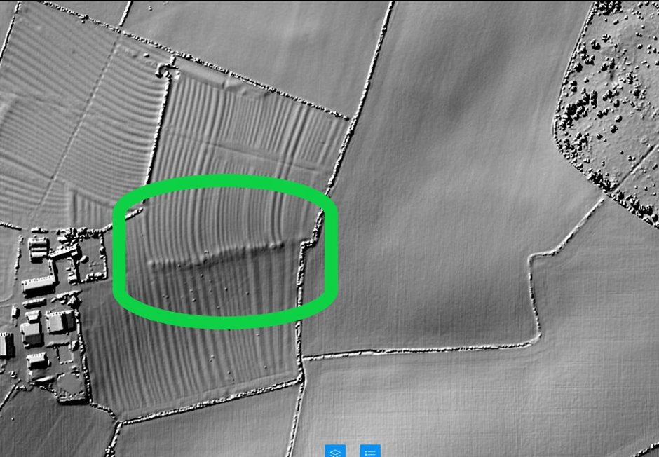
Looking at the LIDAR image, there definitely seems to be some sort of linear feature between the modern farm and the ‘kink’ in the parish boundary.
The feature – which looks like a raised linear earthwork – must logically be older than the medieval ridge and furrow, which runs straight over the top of it.
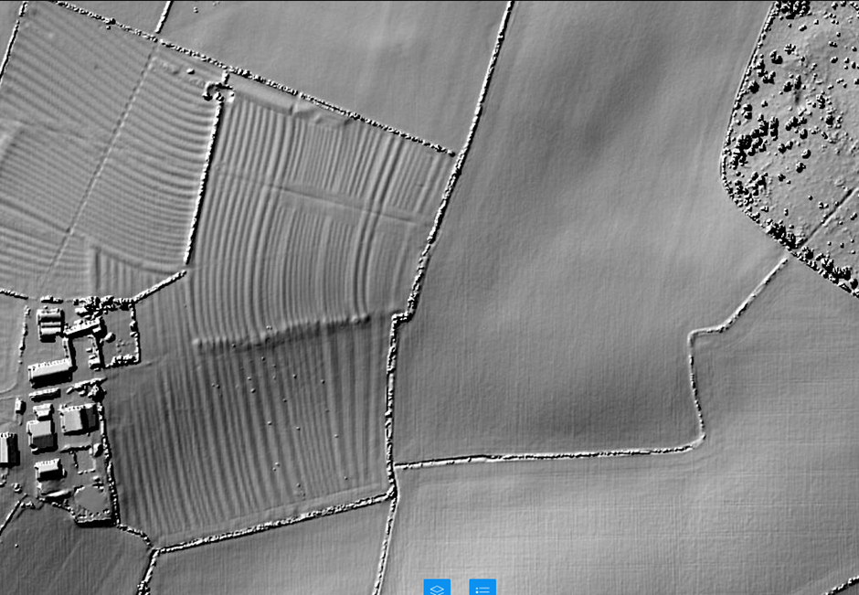
Pulling back on the LIDAR image, the feature is also in line with the farm access road:


(I suspect it’s just a coincidence that the farm access road is in line with the linear feature. The farm access road sits on top of the ridge and furrow, while the ridge and furrow runs over the top of the linear feature.)
A second mystery feature
The eagle-eyed reader will be drawn to the fox covert in the top right of the image. Within the ‘pudding bowl’ shape of the covert, there’s a distinct rectangular depression on a north-west to south-east axis, which may be 250m x 100m. You can get into the fox covert quite easily in the south-east corner and have a walk around; it’s scrub, rather than thickly wooded. The feature isn’t obvious on the ground; if anyone’s got any bright ideas what it is, do drop me a line, and I’ll raise it with the Oadby & Wigston Field Walk Group.

The anomaly in the present and the significance in the past: what’s happening here?
The kink in the parish boundary was at the edge of the cultivated fields; that’s what made it significant in the landscape in the past. When the parish boundary was formalised and laid out the edge of the ploughed land, plus the field headland, was an obvious feature in the landscape, and was ‘marked’ in the parish boundary by a small digression from the general route of the boundary (analogous to the ‘kinks’ in the path of the boundary crosses a roman road; that, too, would have been extant in the landscape, and would have been a memorable and useful ‘hook’ for the line of the boundary).
We know there was a field headland there, because we can still make it out on the LIDAR image.
During the first half of the fourteenth century the population of England grew to perhaps 6 million. The climate was probably balmier and cropping was easier than it had been for decades. However, farming was inefficient. In good years there would be a decent surplus, in poor years, famine. As the population grew, there was a shortage of cultivated land.
The significant thing at this point today is the partial destruction of the field headland. My thesis is that partial destruction occurred in the spring of 1349. The decision had been made at that date to expand the area of cultivation. In my imagined scene, that’s what’s happening.
Prior to that day, the field to the north part of the ridge and furrow we can see had been long cultivated. After that day, the south part of the field – formerly waste land – was ploughed for the first time (that’s ‘waste’ in the sense of unploughed; it will certainly have been used for grazing – it wasn’t ‘waste’ in the sense of scrap land or demolition sites or untended scrub that we might think of as ‘waste’ today.)
I’m arguing it happened in spring 1349 because the field headland was partially, not completely, destroyed by overploughing. We can see from the lidar image that the plough scars run straight over the top of the field headland and have partly, but not completely, removed it. If the decision to extend cultivation had been made in (say )1329 there’d be no headland to see in the modern image; the headland would have been completely rubbed out, with even a few years of medieval ploughing. It wasn’t totally destroyed because the plough team never came back to finish the job.
It’s estimated that 50% of the population died during the black death. Suddenly, there was more than enough land to feed the survivors; and the survivors retrenched onto the ‘core’ cultivated lands of the village.
One of the significant impacts of the black death on the Leics landscape was retrenchment and abandonment of villages on higher or more marginal land – there are a lot of deserted medieval villages dotted round east Leics in particular, and they started to decline after the black death. It’s unlikely that everyone in the more marginal villages simply upped sticks and left that year, but it’s plausible to think that they drifted away over the next few years; there would have been vacant land in better sited villages, and a lord in the next valley may well have been offering better terms for a lease (with a lower rent and less labour obligations, perhaps.)
Thanks
I owe a big debt to John Lacey, who I first met at ROLLR in November 2021. He was looking at the plans for the Abbey Road Pumping Station and I was looking at Enclosure Maps of Glooston and Slawston for traces of the Gartree Road. He highlighted a ‘kink’ in the parish boundary at Port Hill (GR 787933), and that’s what set me off looking for, and at, these anomalies in the first place. I’d spotted this Kilby-Wistow earthwork and ‘kink’, but it was John who identified it as a field headland.
Notes
This field is about 1.5 miles (2.4 km) north-west from the middle of Fleckney. The map I used is OS Map 233 “Leicester and Hinckley.” The ‘kink’ in the parish boundary is at GR 631945.
The field paths are all well marked and in good condition. One point to note; Fleckney has crept slightly to the west since the map was last revised in 2010. The footpath now follows a modern street to GR 641940, where there’s a stile into the fields.
Further Reading & Resources
Either use OS Explorer 233 or, in the alternative, the Ordnance Survey offer an app at OSMaps.com. If you pay a subscription, you can access full OS mapping with familiar fonts and legends, but there’s a free version that is fine – it shows the footpaths and parish boundaries. You can clearly see the ‘kink’ you’re looking for.
‘Village and Farmstead: A History of Rural Settlement in England’ by C Taylor (George Philip, 1983).
‘Village, Hamlet & Field’ by Lewis, Mitchell-Fox and Dyer (Windgather Press, 2001).
‘Shaping Medieval Landscapes: Settlement, Society, Environment’ by Tom Williamson (Windgather Press, 2003) – Williamson is an academic at the University of East Anglia and the book includes a summary of the historiography of landscape history. I think it’s really well written, too; lucid, compelling, empirical, and very far from a theory heavy, ‘ivory tower’ academic text. Strongly recommended, as are other works by Williamson.
‘Leicestershire: An Illustrated Essay on the History of the Landscape’ by W G Hoskins (Hodder and Stoughton, 1957). Outdated (especially for the periods prior to the Roman Conquest and after their departure), and no doubt unfashionable in its tone for a vanishing rural England, it got me out on my bike whilst I was in the Sixth Form and opened my eyes to the palimpsest around me.
The best resource I’ve found for old maps is at the National Library of Scotland’s website; here’s a link. The 25-inch map of Kilby Grange Farm, surveyed in 1885 and published in 1886 is here. You can find LIDAR images here. I came across a really useful parish boundary map here, and this is another really useful link for Ordnance Survey maps. Ordnance Survey maps are available as an optional layer in Bing Maps. Their map of Kilby is here.
