Are anomalies, oddities in parish boundaries a key to see into places of significance in long disappeared early medieval landscapes? I believe they are. We live in a causal universe; there’s a reason why this boundary is here and not there – and when parish boundaries were laid out in a world without maps, they moved between points of significance in the landscape; a stream, a ridge, a summit, a ford. Points on the boundary were carefully selected to be memorable places for those that followed, allowing ‘beating the bounds‘ for countless future generations.
We’d expect a landmark to act as an anchor for a parish boundary – four parishes meet along the ridge of the Langton Caudle, for example. But artificial features seem to be as important as physical geography; I’ve spotted a number of places in the route of a parish boundary where there’s a short, sharp, sudden change of direction – sometimes only a few meters – before reverting to the general route. These anomalies seem to lie on the tracks of Roman roads, suggesting the road was visible in the early medieval landscape when parish boundaries were formalised.
Could similar anomalies – short, unsustained, deviations in the directional track of a parish boundary – be methodically identified and used as initial points of inquiry into landscape history? More specifically, could they be used to identify ‘lost’ tracks of roman roads?
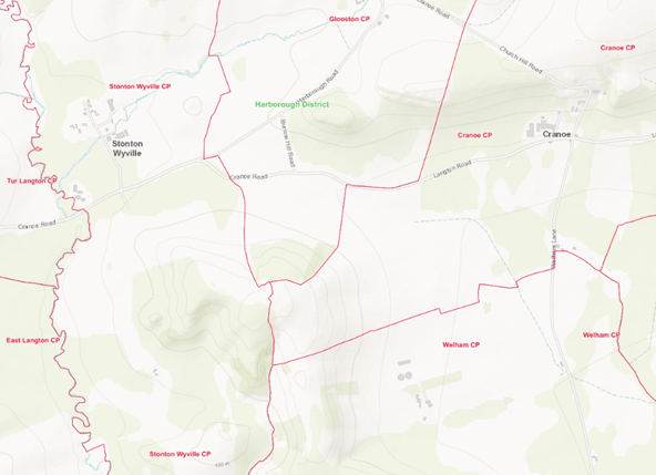
Four parishes – Stonton Wyville, Glooston, Cranoe and Welham meet on the ridge of the Langton Caudle, South West Leicestershire.
Evidence
A review of Margary 57: Huntingdon > (57a) > Leicester > Mancetter
- Margary 57a Huntingdon to Leicester
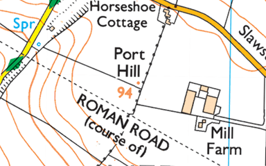
Whilst looking at the track of the Gartree Road in SE Leicestershire a boundary anomaly was pointed out to me, at Port Hill; the parish boundary (the dotted line) takes a sharp ‘kink’ as it crosses the track of the Roman Road before continuing in its general direction:
Slawston – Medbourne Parish Boundary
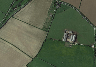
The anomaly in the hedge line is visible on the ground, in ariel photographs:
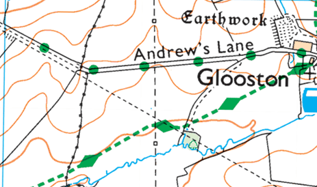
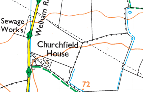
I spotted four further anomalies along the track of the Roman Road at Glooston, Cranoe, Cottingham and Stanion:
Stonton Wyville – Glooston Parish Boundary
Glooston – Slawston Parish Boundary; here, the anomaly is a sharp turn, coinciding with the track of the Roman Road
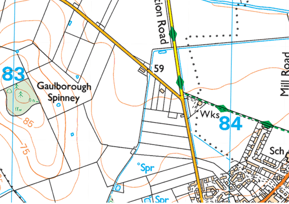
Middleton – Cottingham Parish Boundary; here there is a sharp ‘kink’ as the parish boundary crosses the footpath (the track of the Roman Road) at the works
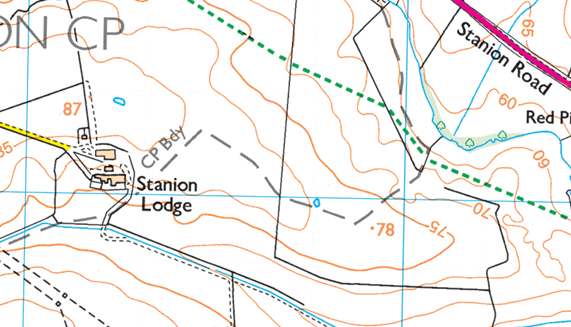
Stanion – Brigstock Parish Boundary
Note: the parish boundary in coincidental with the dashed grey CP Bdy line by Stanion Lodge; here, the parish boundary briefly tracks the course of the Roman Road (running NW to SE along the ridge line)
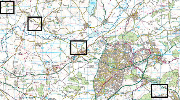
Plotting the four anomalies (Cranoe, Port Hill, Cottingham and Stanion) revealed:
- Margary 57b Leicester to Mancetter
At a macro scale the main roman roads in Leicestershire are clearly visible from a map of parishes:
Watling Street forms the SW border of the County (Margary 1)
Fosse Way (N) from Leicester towards Lincoln (Margary 5f)
Fosse Way (S) from High Cross to Leicester (Margary 5e)
Less clearly, but discernible, the Gartree Road SE from Leicester towards Huntingdon (Margary 57a)
… but Margary 57b from Leicester to Mancetter (although in part it is still in use and is marked on as a road and a Roman Road on Ordnance Survey maps) is not immediately visible at this scale in the parish boundary record.
Can it be ‘found’ using parish boundary anomalies?
There are distinct ‘kinks’ in the parish boundary SW and NE of Fenn Lane Farm along the known (and marked) track of the roman road:
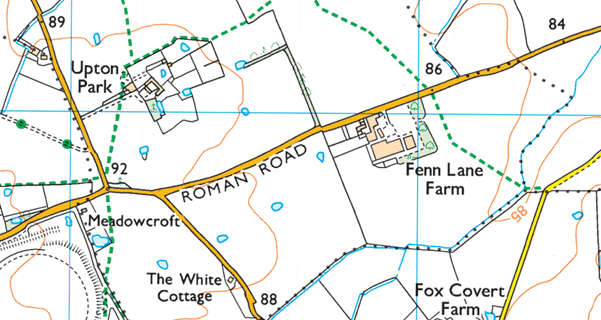
Witherley – Sheepy Parish Boundary and Sheepy – Sutton Cheney Parish Boundary; here there are two anomalies. The first, at point 92, has the parish boundary take a sharp ‘kink’ as it crosses the Roman Road. The second, between points 86 and 84 has the parish boundary briefly track the course of the Roman Road running SW to NE.
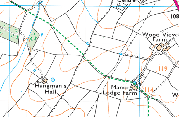
There is a further kink at a pond NE of Hangman’s Hall, where no road (Roman or otherwise) remains, and the track of the Roman Road is not noted:
Sutton Cheney – Peckleton Parish Boundary
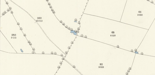
This feature is particularly clear on the 25” OS Map (1885)
An odd-shaped ‘spur’ ensures the parish boundary touches the roman road SE of Hallfields:
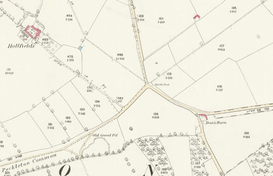
Desford – Leicester Forest West (formerly Peckleton) Parish Boundary
Field Boundaries and farm tracks follow the road (running SW to NE) SW of Kirby Muxloe between The Hollow Farm and Oaks Farm:
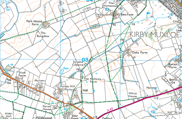
There are further anomalies SE of Kirby Muxloe castle, and a (former) parish boundary between Kirby Frith and Braunstone Frith follows the direction of travel of the Roman Road NE of Kirby Muxloe castle. The road (located through excavation of New Parks Reservoir in the City of Leicester) then takes a SE turn from the (relatively) high ground immediately to the NW of Leicester, via a field track and path to Glenfield Road and SE towards Leicester City Centre.
Plotting the anomalies on Google Maps revealed:
Other
I’ve identified two other boundary anomalies; where a parish boundary meets a ridge and furrow field headland (Leicestershire) and where a parish boundary meets Offa’s Dyke (Denbighshire). Both of these anomalies would support the hypothesis that parish boundaries moved between ‘hooks’ in the landscape extant at the emparishment of the early medieval landscape.
