Some second thoughts … and a second hypothesis:
- Absence of evidence isn’t evidence of absence, but Lee, Derry and the HFWG have looked for traces of the road along the Ordnance Survey’s projected route without success. Perhaps that suggests it’s somewhere else.
- Reynolds identified a diversion in his sketch map (1794) which seems to follow the current Cranoe Road Glooston / Church Hill Road Cranoe road. His route is not a road created during enclosure, because that didn’t happen until 1828. Perhaps the later enclosure road, which certainly seems to sit high in the landscape on a possible agger, followed the disused trackway.
- Reynold’s route does not appear on the 1814 Ordnance Survey Drawing (or the One Inch First Series Map of 1862, for which the Drawing was the preliminary survey. Note that the 1828 enclosure of Glooston and Cranoe meant that 1862 map was thirty-four years out of date when it was published and is seriously misleading – it shows the pre-enclosure open fields and trackways pre-1828, not as they were in 1862.) Perhaps Reynold’s route was not in use as an active field track in 1794, or 1814 when the Ordnance Survey visited the parish.
- The Victoria County History doesn’t think the road follows the Ordnance Survey’s projected route.
- The Ordnance Survey Archaeology Department seem to have started with a projected line on map, and looked for evidence to support it, rather than the other way round. The evidence that they did find in the ‘gap’ was not terribly conclusive.
- ‘Roman’s Farm’ appears to have been built by 1885 (from the mapping evidence) and to have taken its name from the extant, physical track by which it accessed the Welham Road in Slawston (at SP 775940) prior to the construction of access to Commissioner’s Lane towards Slawston Village. Gartree Road is marked and named on the 1885 25” map running south east towards Medbourne (but not running north west towards Glooston.
- The field boundary running north west from Roman’s Farm is a striking feature of the landscape, before making an abrupt turn towards Cranoe, suggesting a deliberate, measured, regular-lined diversion from the line of the road coming up from the Welland Valley to avoid the marshy ground between Church Field House, Welham, and Slawston. The Roman army surveyor decided to stick to the shoulder of the low hill Medbourne – Slawston – Cranoe, having recently escaped from the flood plain of the Welland and its unnamed tributary running north west towards Church Field House).
- The surveyor of the Gartree Road avoided other obstacles on the ground locally. Margery (Roman Roads in Britain Volume I, Phoenix House, London: 1955 at p188) makes the point that the deviation around Carlton Curlieu Manor House “may well be original to avoid a hollow, for a parish boundary follows it.”
- Approaching from the south east and having crossed the Welland, the Roman Road is at 65m south east of Medbourne; 75m south west of Medbourne; 90m at the shoulder of Port Hill before dropping to a spring at 75m. Beyond this point, to the Langton Road at Cranoe, the proposed alternative route remains at or above the 80m contour. If the ‘Roman Road – course of’ route marked on the OS map is followed, the road drops below the 75m contour and crosses a number of modern drainage ditches (including the outfall from the Sewage Works) indicative of earlier marshy ground.
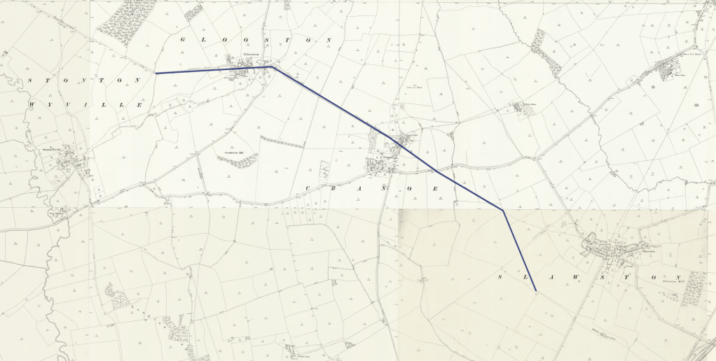
A Proposed Route…..
Gartree Road passes along Andrew’s Lane through Glooston; along Cranoe Road / Church Hill Road into Cranoe; perhaps passes immediately south of the St Michael’s Church, carries straight on down the slope in a straight line to the Langton Road at SP 765951, crosses the Langton Road following the public footpath marked to the parish boundary, crosses the stream (briefly diverging from the footpath which follows the hedge line) before regaining the public footpath at SP 769948. From this point the Roman Road follows the public footpath south-south-east to Romans Farm before turning left, regaining the Gartree Road as marked from physical survey on old OS mapping. The course of the Roman Road is then as marked on the current (and prior) OS mapping; to Welham Road, Green Lane and via the shoulder of Port Hill to Medbourne.
Proposed route superimposed on the 1904 twenty-five inch OS Map: